
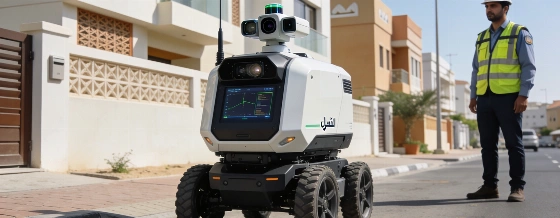
Dubai has taken a new approach to city mapping. The municipality now uses an AI-powered robot for geospatial and cadastral surveys, a move confirmed by Emirates News Agency (WAM). This robot has sharply reduced survey waiting times-by hundreds of days in some cases-and cut operational costs by 90%. The project supports the Dubai Economic Agenda D33, which focuses on digital transformation and smart city infrastructure as the city grows.
The robot was first put to work at the Wadi Al Amardi housing project. There, it handled final building surveys and issued certificates much faster than before. WAM reports that the robot eliminated 472 days of customer waiting time, shortened fieldwork by 24 days, and saved 40 hours of office processing. By switching from traditional 2D mapping to detailed 3D point clouds and panoramic façade images, Dubai has raised the standard for data quality in urban development.
How the robot changes city data collection
The robot uses advanced sensors: LiDAR for precise mapping and smart cameras for panoramic images. It can operate on its own for long periods, moving through complex areas with little human help. Zawya has confirmed that this technology keeps Dubai Municipality's spatial database up to date with accurate information, which is essential for planning, asset management, and city decision-making. The rollout also fits with the UAE Vision 2031, which calls for more AI and automation in government services.
Automating surveys also improves safety. Fewer field crews are needed in risky or hard-to-reach places, which means less exposure to hazards and higher productivity. This shift to AI-driven mapping is not only about speed-it also makes the process safer for workers, as recent WAM reports have noted.
Leadership and future plans
Meitha Al Nuaimi, Director of the Geographic Information Systems Centre at Dubai Municipality, described the robot as "one of the smart solutions developed to enhance the efficiency of geospatial data collection." The municipality plans to use this technology in more residential communities and to further integrate it into field survey work. This approach follows guidance from the Dubai Media Office and supports Dubai's goal to lead in smart city innovation in the Gulf region.
Dubai's investment in tools like the AI survey robot is already changing how infrastructure projects are planned and managed. As reported earlier, Dubai authorities are moving quickly to adopt AI across public services. The robot's ability to deliver detailed 3D data supports urban planning, asset management, and regulatory compliance, in line with standards from the Dubai Land Department and the Central Bank of the UAE.
By automating city mapping, Dubai Municipality is setting a new standard for urban management in the region. Faster, safer, and more detailed data is now available for residents, developers, and city planners. The days of slow, manual surveys are ending, and Dubai is moving ahead with smarter tools for city building.